 Kontakt
 Kako kupovati
Dostava
Savjetnik za kupnju
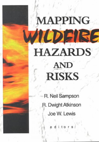
Mapping Wildfire Hazards and Risks
 Engleski
 233 b
233 b
 Pripremamo
 Termin nepoznat
Do 30 dana za povrat
Kupci su kupili i


 /
/
 Meki uvez
 19.30
€
19.30
€

Develop accurate computer models to determine wildfire risks and controlled-burn benefits!Although scientists now recognize that fire is essential to many ecosystems, the ecological and political issues of managing wildfire continue to be vexing. Mapping Wildfire Hazards and Risks offers multiple perspectives on using a Geographic Information System (GIS) for more effective wildfire management. This innovative technology is the ideal tool to organize and display all the information available, so authorities can make informed judgments based on all the facts.Because the authors are not merely theorizing but discussing the GIS they are actually building and using, Mapping Wildfire Hazards and Risks offers practical ideas and perspectives, including:
- specific information on the modeling approach and kinds of data utilized
- valuable discussions of the social and environmental factors included in the model
- techniques for predicting the effects of wildfire on neighborhoods, soil erosion, sedimentation, and air quality
- predictions of long-term ecosystem recovery given wildfires of different sizes and intensities
- maps, charts, tables, and formulas to make the process of building a GIS understandable and accessible


Informacije o knjizi
Engleski

Poklonite ovu knjigu još danas
To je jednostavno
1 Dodajte knjigu u košaricu i odaberite isporuku kao poklon 2 Zauzvrat ćemo vam poslati kupon 3 Knjiga dolazi na adresu poklonoprimcaMoglo bi vas zanimati i

 /
Meki uvez
46.09
€
/
Meki uvez
46.09
€


 /
Meki uvez
7.67
€
/
Meki uvez
7.67
€

 /
Meki uvez
15.66
€
/
Meki uvez
15.66
€


 /
Meki uvez
6.76
€
/
Meki uvez
6.76
€

 /
Meki uvez
31.63
€
/
Meki uvez
31.63
€


 /
Meki uvez
25.97
€
/
Meki uvez
25.97
€
Dobar dan! Ja sam Libroamiko, vaš književni savjetnik.
Kako vam mogu pomoći?